|
Click on images to see larger
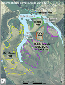
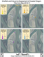
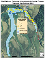
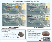
The information we collected during the shellfish and estuarine assessment in 2010-2012 enabled us to map the location, density, and associated habitat features of bay clams in Tillamook Bay. The two types of maps presented on this webpage display where we found clams during our survey.
The first type of map is the Clamming Maps of Tillamook Bay. These maps present the bay clam densities in recreationally important clamming areas. The four bay clam species include cockle, gaper, butter, and native littleneck clams.
The second type of map is the SEACOR Research Result Maps which focus on the clam densities in a specific region of the bay. These maps show SEACOR study results for each part of the bay.
| Recreationally important clamming areas sampled during the study |
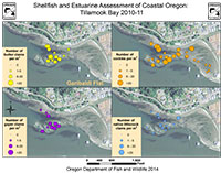
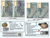
Garibaldi Flat
Garibaldi Flat is the primary recreational flat for bay clam harvest in Tillamook Bay. The western portion of Garibaldi Flat is dominated by cobble and gravel. The eastern part of the flat near the Coast Guard station is sandy with a small eelgrass bed and plentiful shrimp beds. The western cobble-dominated environment supported the highest densities of cockles, butters, and native littlenecks. While these clams were dense, they tended to be smaller than clams found in Middle Flat or Bay Ocean.
Garibaldi Flat Clam Densities (pdf) |
|
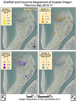
Middle Flat
Middle Flat is accessible only by boat and is situated next to the Main subtidal channel. While it has not been a major site for recreational harvest, this region has been the primary location for the intertidal commercial cockle rake fishery since 2003. Middle flat is a mostly sandy region. The western peninsula of this intertidal flat was not sampled since it is a harbor seal haul-out area. Of the four bay clam species, cockles and gapers were more common.
Middle Flat Clam Densities (pdf)
|
|
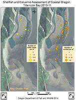
Bay Ocean Flat
Bay Ocean is characterized by a large, extensive eelgrass bed. The deep pool in the north is a popular fishing spot. Currently, this area is the primary site for commercial oyster leases in the bay. All four species of bay clams were found on Bay Ocean Flat; however, native littleneck clams were less common.
|
|
| Other areas sampled as part of this study |
Middle Islands (Fog, Muck, Duck, and Torch Flats)
Fog Flat is a mostly sandy area with limited recreational effort for bay clams. However, ghost shrimp are harvested commercially as bait. The other middle islands are characterized by high eelgrass cover and burrowing shrimp beds. The Middle Islands did not support many clams. Butters and native littleneck clams were entirely absent from all sites surveyed at these islands.
|
|
Subtidal Channels (Hobsonville, Main, and Bay Ocean Channels)
The subtidal channels are areas of the bay that remain covered by water even at low tide. Often these areas are important regions to study when trying to understand clam densities of the whole bay system.
Hobsonville Channel is the historical location for commercial dive fisheries in Tillamook Bay. The southern portion of this region is now closed to commercial subtidal clam harvest. All the target clam species were found in this channel, however butter and cockle clams were most abundant.
Main Channel is a rocky and cobble-dominated deep channel with strong tidal currents. Most of the current commercial dive fishery effort, which has recently focused on cockle and gaper clam resources, occurs within this area. This channel exhibited high densities of many of the clam species.
Bay Ocean Channel is the largest marine-influenced channel in Tillamook Bay and surrounds recreationally important flats. Few clams were observed in this channel. Both butter clams and native littleneck clams were absent from the sites surveyed in this region.
|
|
Overall, we found that region and habitat affect the distribution and number of the species we investigated.
Directions to Tillamook Bay clamming access points (pdf)
Contact the SEACOR project via e-mail at:
ODFW.SEACOR@odfw.oregon.gov |
